

GIS Implementation

Asset Management

Technical Operations and Maintenance Management

Business Process Management

Mobile Data Collection

Fleet Management
Facilities Management

Environmental Health Management

Inspections Management

Live Geotechnical Hazard Maps for Mining

Geotechnical Inspections for Mining
GISCOE offers a comprehensive approach to GIS implementation, ensuring that organisations can fully leverage spatial technologies to achieve their goals. Our process begins with an in-depth assessment of client needs, followed by the design of customized GIS solutions that align with operational requirements. We oversee the installation and configuration of GIS systems, integrating them seamlessly into existing infrastructure. Post-implementation, we provide training and ongoing support to ensure long-term success. Whether it’s for municipal management, utility services, or private sector operations, GISCOE’s implementation services are designed to deliver measurable outcomes, enhance data management, and improve decision-making.
Managing physical and infrastructure assets is critical for organisations striving for efficiency and longevity. GISCOE’s asset management solutions use spatial data to provide a comprehensive view of assets such as roads, buildings, pipelines, and electrical networks. Our solutions enable clients to track asset lifecycles, monitor conditions, and schedule maintenance proactively. By integrating GIS technology with asset management systems, we ensure organisations can optimize resource allocation, reduce downtime, and comply with financial reporting standards such as GRAP and mSCOA. These solutions provide detailed dashboards, analytical tools, and automated reports to support strategic planning and decision-making.
GISCOE’s solutions for technical operations and maintenance management focus on enhancing efficiency in critical organisational workflows. Using GIS as a core component, we develop systems that allow organisations to monitor infrastructure, track work orders, and manage resources in real time. Whether it’s for municipal services, utilities, or private enterprises, our solutions enable proactive maintenance, reducing unplanned outages and increasing operational reliability. GISCOE integrates spatial data with advanced analytics to provide actionable insights, allowing organisations to prioritize maintenance activities and allocate resources effectively.
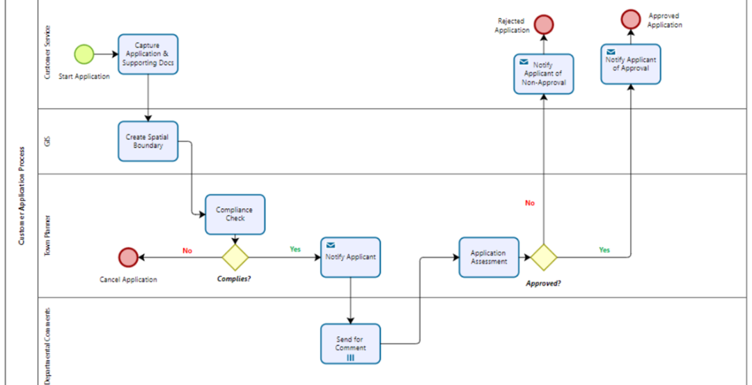
Our business process management (BPM) solutions integrate GIS with process automation to optimize organisational workflows. GISCOE develops GIS-centric systems that align business processes with operational goals, ensuring efficiency and transparency. For example, workflows such as permit approvals, land-use planning, or public works projects can be automated and spatially enabled, allowing for better coordination across departments. By integrating GIS into BPM, organisations can visualise the spatial impact of their processes, identify inefficiencies, and make data-driven improvements. This results in faster service delivery, improved compliance, and enhanced collaboration across teams.
GISCOE’s mobile data collection solutions are designed to provide organisations with the tools they need to capture accurate, real-time data in the field. Using our G-Forms platform, users can utilise custom forms linked directly to centralized databases. This allows field teams to collect data such as infrastructure conditions, environmental information, or survey results using mobile devices like smartphones and tablets. The collected data is synchronized with GIS platforms, enabling real-time updates and analysis. This solution reduces manual errors, streamlines workflows, and improves data accuracy, making it ideal for utilities, municipalities, and environmental projects.
Managing fleets efficiently is crucial for organisations with mobile operations, and GISCOE’s fleet management solutions provide the tools needed to optimize these resources. By integrating GIS with fleet management systems, we enable organisations to track vehicles in real-time, plan optimal routes, and monitor fuel consumption. Our solutions also support preventive maintenance scheduling, ensuring vehicles remain operational and safe. With GIS-centric dashboards and reporting tools, clients gain insights into fleet performance, enabling better decision-making, reduced costs, and improved service delivery.
GISCOE’s facilities management solutions leverage spatial technologies to provide organisations with a detailed understanding of their physical assets and spaces. Our systems allow clients to visualise building layouts, track space utilization, and monitor maintenance activities. By integrating GIS with facilities management tools, organisations can streamline operations such as scheduling repairs, planning renovations, or managing energy consumption. These solutions are particularly beneficial for large facilities such as hospitals, campuses, and corporate buildings, where efficient management can lead to significant cost savings and improved user experiences.
Environmental and public health are closely linked, and GISCOE’s environmental health management solutions are designed to address challenges in this critical area. Our systems integrate spatial data with health and environmental metrics to provide a clear picture of risks and resources. For example, clients can monitor air and water quality, track disease outbreaks, or plan environmental mitigation efforts. GISCOE’s solutions enable organisations to comply with environmental regulations, respond to emergencies more effectively, and implement proactive measures to safeguard public health.
Effective inspections are essential for ensuring compliance and maintaining operational standards, and GISCOE’s inspections management solutions simplify this process. Using GIS-enabled mobile applications, inspectors can schedule, conduct, and document inspections in the field. These systems allow for real-time updates, photo attachments, and GPS-tagged data, providing a comprehensive record of inspection activities. The collected data is integrated with GIS platforms, enabling organisations to visualise inspection results and identify areas needing attention. This solution is ideal for infrastructure inspections, environmental compliance, and public safety assessments, ensuring organisations stay compliant and proactive.
GISCOE provides advanced Live Geotechnical Hazard Maps to enhance safety and operational efficiency in the mining industry. These dynamic, GIS-powered maps deliver real-time visualization and monitoring of geotechnical risks, such as slope stability, ground movement, and subsidence. By integrating data from sensors, drones, and field reports, the maps provide a comprehensive view of geotechnical conditions across mining sites. This enables proactive identification of hazards, informed decision-making, and immediate response to potential risks. Our live mapping solutions empower mining operators to improve safety compliance, reduce downtime, and optimize resource extraction while safeguarding workers and infrastructure.
GISCOE’s Geotechnical Inspection solutions are designed to streamline and enhance the inspection processes critical to mining operations. Leveraging mobile GIS tools, inspectors can efficiently collect, record, and analyse geotechnical data in the field, such as rock mass quality, slope angles, and structural integrity. The collected data is geotagged and directly integrated into centralized GIS systems, enabling real-time updates and analysis. This solution ensures accurate documentation, faster reporting, and the ability to track inspection trends over time. By providing actionable insights into geotechnical conditions, GISCOE helps mining operators minimize risks, ensure compliance with industry regulations, and maintain safe and sustainable operations.
This site was created with the Nicepage